40 - 40 de 40 resultados

Garmin GPS / Plotter 278C GPSmap (cartografía terrestre de Europa incluida)

0,00
Precio sin IVA, más entrega


Description:

* The new Dual use Marine/Auto GPSMAP 278 has the following main features

* Marine / Road navigation, only unit of its type available.

* Fully portable and waterproof.

* Uses Optional BlueChart® g2 datacards.

* Pre-loaded City Navigator® NT street mapping for Europe.

* Full UK Postcode Search.

* Very easy to use.

The GPSMAP 278 is Pre-loaded with European City Navigator® NT street detail including Eastern Europe.
Select a destination on land and get automatic routing with voice-prompted turn-by-turn directions.

Accepts optional g2 data cards for detailed marine cartography and City Navigator® street level mapping.
Full UK postal code search.
Audio jack provides connection to headphones or cassette adapter.
Provides voice prompt guidance when the 12-volt speaker cable is connected.
Rechargeable lithium-ion battery offers 4 to 15 hours use.
Audible alarms for anchor drag, arrival, off-course, proximity waypoints, external voltage and clock.

Offers BlueChart® night mode for easier viewing at night time.
Built-in tide tables and celestial tables for sun and moon calculations.
Large numbers option for easy viewing.
Optional GSD21 for full feature sonar capability.
Sunlight readable 3.8 inch diagonal TFT colour display (480x340 pixels) with adjustable backlight.
3000 user waypoints with an expanded list of waypoint symbols.
50 reversible routes with 300 waypoints per route.
10,000 point automatic track log; 15 saved tracks, 700 saved track points each.
WAAS-enabled, 12 parallel channel GPS receiver.
Adjustable quad helix receiving antenna with remote antenna capability.
Unit dimensions: 5.7"W x 3.2"H x 1.9"D.
Waterproof, IEC 60529, IPX7 (submersible to 1 metre @ 30 minutes).
Position formats include Lat/Lon, UTM, Loran TDs, Maidenhead, MGRS, User and more.

The package includes

GPSmap 278 unit with internal memory pre-loaded with full Europe City Navigator NT data.
City Navigator® Europe DVD.
USB interface cable, power/data cable.
Marine mount.
Automotive mount which includes the cigarette lighter with speaker.
Rechargeable lithium-ion battery.
AC adapter.
Owner's manual.
Quick reference guide.

* NB. The image is of the GPSMAP276C and not the 278, however the two units are identical in appearance and use the same accessories.

Specification:

Navigation features
Waypoints/icons: 3000 with name and graphic symbol, 10 nearest (automatic), 100 proximity

Routes: 50 reversible routes with up to 300 points each, plus MOB and TracBack® modes

Tracks: 10,000-point automatic track log; 15 saved tracks, 500 points each, let you retrace your path in both directions

Trip computer: Current speed, average speed, resettable maximum speed, trip timer, and trip distance

Alarm clock: Anchor drag, approach and arrival, off-course, proximity waypoint, shallow water, and deep water

Tables: Built-in celestial tables for best times to fish and hunt; sun and moon rise, set, and location

Map datums: More than 100 plus user datums

Position format: Lat/Lon, UTM/UPS, Maidenhead, MGRS, Loran TDs, and other grids, including user grid

GPS performance
Receiver: WAAS-enabled, 12-parallel-channel GPS receiver continuously tracks and uses up to 12 satellites to compute and update your position

Acquisition times:

Warm: Approximately 15 seconds

Cold: Approximately 45 seconds

AutoLocate™: Approximately 5 minutes

Update rate: 1/second, continuous

GPS accuracy:

Position: < 15 meters, 95% typical*

Velocity: 0.05 meter/sec steady state

DGPS (USCG) accuracy:

Position: 3-5 meters, 95% typical

Velocity: 0.05 meter/sec steady state

DGPS (WAAS) accuracy:

Position: < 3 meters, 95% typical

Velocity: 0.05 meter/sec steady state

Dynamics: 6 g’s

Interfaces: USB, RS232 with NMEA 0183, RTCM 104 DGPS data format and proprietary GARMIN

Antenna: Removable quad-helix

Differential: DGPS, USCG and WAAS capable

Moving map features
Basemaps: Autoroute, Atlantic
Uploadable maps: Accepts a Garmin data card which may be loaded with a variety of optional MapSource CDs, including BlueChart marine cartography, City Select, and Fishing Hot Spots.

Power
Battery: Rechargeable lithium-ion

Battery life: 5 to 15 hours depending upon the backlight setting

Source: 11-35 Vdc

Fuse: 3AG - 1.5 Amp

Physical
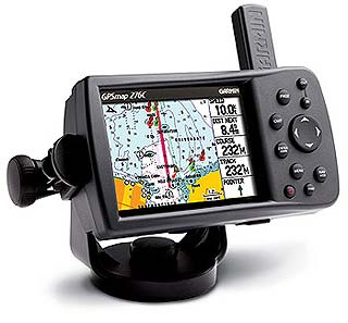
Size: 5.7" W x 3.2" H x 1.9" D (14.5 x 8.1 x 4.8 cm)

Weight: 13.6 oz. (0.39 kg)

Display: 3.75" diagonal (9.5 cm) transflective, 256-color display with backlighting (480 x 320 pixels)

Case: Fully gasketed, high-impact plastic alloy, waterproof to IEC 60529 IPX7 standards

Temp. range: 5ºF to 140ºF (-15ºC to 60ºC)

Examine también estas categorías: Garmin, Garmin
40 - 40 de 40 resultados