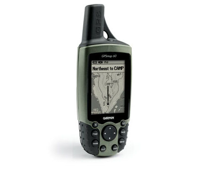
GPS Garmin GPSMAP 60
El GPSMAP 60 es la solución para quien busque un posicionamiento GPS preciso para navegación terrestre y marina a bajo coste con un nivel alto de detalle.El GPSMAP 60 tiene 24 MB de memoria interna que podemos utilizar para transferir al equipo mapas detallados marinos (BlueChart) y terrestres (City Select). También incluye un mapa base internacional con capacidades de ruta automática. La cartografía City Select, incluída en un Kit de automoción opcional, convierte al GPSMAP 60 en un práctico navegador de coche con capacidad de auto-ruta mediante indicaciones giro a giro sin voz. El equipo incluye: Clip cinturón CD Trip & Waypoint...
Además de las características comunes a toda la serie 60 de GPS portátil de Garmin (descritas en el mod. GPS60 en esta página), el modelo GPSMAP60 incluye:
-Memoria interna de 24 Mb para descargar cartografía náutica BlueChart o terrestre CitySelect
-Incorpora cartografía base terrestre
- 500 waypoints, 50 rutas y 10.000 puntos de track
-Convertible en navegador de coche (sin voz) añadiendo un kit opcional de automóvil con software de guiado por calles, giro a giro.
Descripción
With a new rugged case design, the GPSMAP 60C includes many exciting features such as a TFT, 256 colour display, producing one of the brightest, sunlight-readable displays available.
Detailed maps may be transferred to the unit using the USB interface. Navigation instructions can be communicated to repeaters, plotters and autopilots using NMEA protocols through the dedicated serial port.
The unit includes a built-in International basemap with auto-routing capabilities. Completely waterproof with battery life exceeding 25 hours, the GPSMAP 60C is ideal for both marine and recreational users.
Garmin have included their new MapSource Trip & Waypoint Manager software with the unit. This allows the transfer of waypoints, routes and tracks between you’re the GPS unit and your PC. It includes a general world-wide basemap which can be viewed on the PC, providing basic cartography including motorways, cities, oceans and various other background features for general reference. The software is an excellent basic tool for manageing and archiving waypoints, routes and tracks for later use.
The receiver is fully compatible with MapSource products like BlueChart and City Select, providing streets for turn-by-turn guidance (there is no voice output) on 56MB built-in memory.
A special Geocaching Navigation Mode is included to help you get the most out of the sport. The compass page becomes tailored to geocaching, while notes and hints can be displayed on screen if the cache waypoint includes such comments. When a cache is found, the unit will log an entry into the outdoor calendar and can be used to show the next-closest cache.
To round-off the feature list, the unit also boasts four geolocation games - Virtual Maze, Nibbons, Geko Smak and Memory Race.
Note: Use with MetroGuide software is not recommended with this product
")